


There is one company that has consistently filmed North Korean shipyards and parade rehearsals, areas where foreign media access is extremely restricted. That company is Vantor, a U.S. satellite imagery firm. In October last year, the company changed its name from its former identity, Maxar, to Vantor. Along with the name change, the company's business focus has shifted toward "spatial information services," which integrate and sell data from satellites, drones, and ground sensors as a unified package.
In an interview with MoneyToday, Song Hyun, Vantor Korea representative, explained, "We are evolving from a business that sold videos separately into a comprehensive spatial information solutions provider. We help customers—whether governments or private companies—take control of information operations without needing to own satellites directly."
"More Important Than Satellite Imagery Is 'Time-Series Data'"
Vantor has launched 10 satellites into low Earth orbit (LEO) at an altitude of 500 kilometers, capturing images of 6 million to 7 million square kilometers of the Earth's surface daily. The maximum resolution is 30 centimeters, meaning each pixel in the captured imagery corresponds to a 30-centimeter area on the ground.
During its time as "Maxar," the company primarily focused on selling satellite imagery as individual transactions. However, customer demands have shifted beyond mere images toward "spatial information." Song Hyeon (CEO) stated, "We can comprehensively observe not just whether a certain object exists at a specific location, but also 'behavioral patterns,' such as where that object was one hour ago. Customers are seeking time-series data containing such information, and our current core business involves fusing satellite imagery with ground data to sell it as unified spatial information."
Vantor may not be a familiar name to the general public, yet photos taken by Vantor satellites and spatial information derived from them are already embedded in countless consumer products. When users enable satellite map features on navigation apps like Google Maps, the source attribution at the bottom frequently displays "Maxar" or "Vantor." Song (CEO) noted, "It is estimated that over 1 billion global users of navigation apps utilize Vantor's spatial data."
Vantor's satellite imagery is recognized as authoritative worldwide. According to Vantor, 90% of the foundational geospatial information utilized by the U.S. government is based on Vantor technology. The company has secured an option extension contract worth $70 million (approximately 95.6 billion won) with the U.S. National Geospatial-Intelligence Agency (NGA) and operates a geospatial information platform used by over 250 institutional investors. In Korea, certain government agencies and public institutions are currently utilizing Vantor's services for defense and intelligence purposes. The service "Maritime Sentry," which tracks vessels engaged in illegal fishing at sea while disabling their location signals, is even used as legal evidence for vessel seizures in some countries.
"Even Customers Without Satellites Can Possess 'Information Sovereignty' Through Sovereign Intelligence"
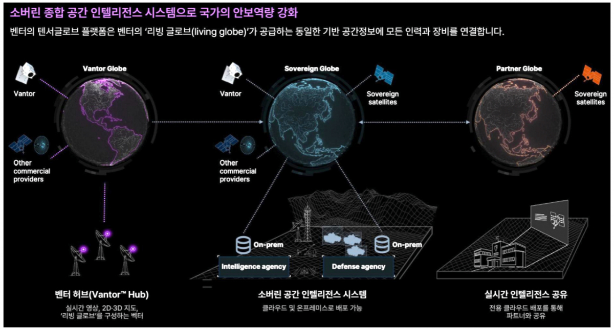
Through its owned satellites and technological capabilities, Vantor aims to provide nations lacking their own satellite constellations with independent spatial information sovereignty, termed "sovereign intelligence." Song Hyeon (CEO) explained, "For information sovereignty, it is not essential for a country to own a satellite system; the essence lies in securing an independent surveillance and monitoring framework. For instance, when Vantor's satellites pass over the Korean Peninsula, control of those satellites would be fully transferred to Korea. The focus should be on control rights rather than ownership."
This approach was first concretized in Europe. In June, Vantor signed a memorandum of understanding (MOU) with German defense contractor LINE-Metal to establish an independent spatial information framework for Germany and Europe. This involves combining Vantor's satellite and spatial information technologies with the capabilities of local defense enterprises.
Vantor's imagery is acquired through optical camera capture. While this method has limitations compared to rapidly growing synthetic aperture radar (SAR) imagery—such as susceptibility to weather conditions like clouds—it offers advantages, including the ability to identify specific colors and text. Song (CEO) explained, "When seizing illegal vessels, it is necessary to identify vessel colors and hull numbers. High-resolution optical imagery can provide supplementary information that complements SAR."
"Analysis Is More Important Than Satellite Imagery Itself," Emphasized Song (CEO). He stated, "I often encounter cases where companies purchase imagery and accumulate data but fail to extract useful information. For such clients, we diagnose that they need a monitoring platform rather than satellite imagery alone."
"Beyond Satellites... Even Drones: Fundamental Prevention of Jamming"

Vantor's expansion extends beyond satellites. In July, the company unveiled "WorldView 3D," which provides customers with updated 3D terrain information within 24 hours after requesting satellite imagery capture.
The application of this 3D terrain data to drones is called "Raptor." Drones store 3D models and compare them in real time with camera footage to determine their location, calculating current position and ground coordinates without GPS signals. Song (CEO) stated, "Since only two elements—the stored 3D model and the captured video—are compared, the system is unaffected by external noise. It has a structure that fundamentally prevents jamming." Countering GPS interference is currently recognized as a common challenge for both the military and the drone industry.
Vantor plans to add observation satellites with short revisit cycles named "Pulse" in 2027, followed by ultra-high-resolution "Vantage" satellites with 20-centimeter resolution in 2029. Song (CEO) emphasized, "In addition to high-cost services used for operational and security situations, we can offer a variety of products tailored to each customer's budget. Our top priority is ensuring customers have access to precise spatial information data when they need it."
[MoneyToday startup media platform 'Unicorn Factory']

 in FUTURE


